Natural Park of Wadi Ar-Rayyan

Wadi Ar-Rayyan is a valley in the middle of Fayoum Governorate in the Sahara Desert (known in Egypt as the Western Desert). It was declared a natural protected area in 1989. Two artificial lakes have been created in Wadi Ar-Rayyan in 1973 when it had been submerged low desert by agricultural drainage water surplus through the establishment of an open channel extending about 9 km length connected to a 8.5 km tunnel, in order to reduce the ground water level in the surrounding areas of Lake Qaroun. The natural park covers 11,434 hectares of lakes, 1,583 hectares of wetlands, and 160,949 hectares of desert lands. Nearby, Wadi Al-Oyoun oasis covers 1,935 hectares. In the winter, lakes are rich of various types of migrating aquatic birds. The desert, on the other hand, includes attractively appealing landscapes such as sand dunes and rare formations of the uninhabited desert oases.
Archeological Park of Wadi Al-Hitan
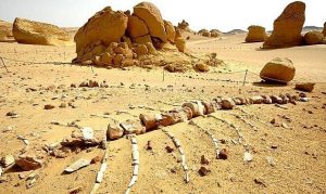
Wadi Al-Hitan ('Whale Valley') is situated in the Western Desert of Egypt, in El-Fayoum Governorate, around 150 km south-west of Cairo. It contains countless fossil remains of one of the earliest species of the extinct suborder of whales, Archaeoceti. Besides being a protected area, the site was declared a world natural heritage site by the UNESCO in 2005. The Valley of the Whales (or the Zeuglodon Valley) was discovered in 1936 and ever since, it became an open museum that dates back to 45 million years and contains petrified primitive whales skeletons, shark teeth , shells and roots of mangroves preserved in soft rocks. Some of the amazing discoveries in the valley is the large walking whale, which once had feet and used to walk on the shore before getting into water. It is called Ambulocetus natans, moved easily between land and sea. Having the size of a walrus, it inhabited coastal environments. With the fossils found, much information about the life of flora and fauna are driven. It is worth noting how clearly these fossils represent one of the major stories of evolution: the emergence of the whale as an ocean-going mammal from a previous life as a land-based animal. This significant phase of evolution is vividly demonstrated at this site. What also distinguishes the area is the existence of movable sand dunes, four natural sulfuric springs, plant groups that contain 15 species of desert plants, about 15 types of wild mammals (such as the white deer, the Egyptian deer, fennec fox (sand fox), red fox and others), 16 species of reptiles, as well as over 100 species of resident and migrating birds.
Qaroun Lake
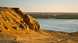
Lake Qaroun (ancient Lake Moeris) is a nature reserve in the governorate of El-Fayoum. It was declared a nature reserve in 1989 with a view to protecting and conserving the area's biological, archaeological and geological diversity. The reserve comprises 1155 km2 of land and 230 square km of water. The lake is rich with various kinds of fish 45 meters below sea level in addition to many charming species of mammals, reptiles and birds. Besides, many archaeological and geological formations can be obtained from the rare fossils the reserve contains. One can immerse in the splendid view of 88 species of birds (including flamingoes) gracefully flying around their nests nearby the lake. For a long period, the lake was too salty for fish, until some marine species – including eel, mullet, sole and shrimp – were brought in the 1970's. Among the several monuments the reserve contains are: El-Sagha (Goldsmiths) Palace from the Middle Kingdom, Abu Lifa Monastery, as well as the remains of the old town of Skitnopius.
Springs of Ain EI-Sileyin
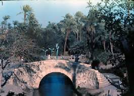
The natural Springs of Ain EI-Sileyin (Ayn of Silieen or Ein EI Saileen) are nestled in the heart of the Fayoum Delta, 8 km far from the city of El-Fayoum. Ain EI-Sileyin's orchards are famous for their fruitful apricot and mango trees. Here, one can eagerly devour the most delicious and purest honey ever. At the site, there are many accommodating facilities, among which are a cafeteria, a swimming pool, and chalets for rent. One can also enjoy viewing various types of date palms and products on regular display. One of the area's attractions is the Water Mill (now obsolete), which was built in 1950 to grind wheat and corn.
Sawaqui El Hadir
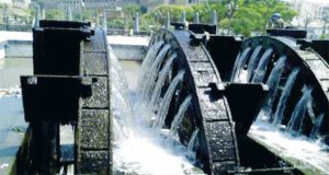
The Sawaqui (or waterwheels) were first introduced to El Fayaoum by the Ptolemies (305-30 BC) to serve their planting plans in Egypt. They were used in the irrigation of fields and orchards in the city. Fayoum has a great number of water wheels, perhaps as many as 200. Sawaqui El Hadir (the Seven Waterwheels of El Hadeer) are still functioning in El-Fayoum by lifting up water to a level where it could be transported into the fields for irrigation. They had had their pivotal role in pushing the economical wheel of the city in particular and the whole country in general starting from the 3rd century BC.
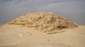
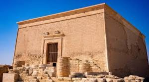
Pyramid of Senusert II
Once covered by a layer of limestone, the Pyramid of El Lahun (known as the Pyramid of Senusert II) was the first large mud-brick pyramid. Its limestone layer was removed during the Nineteenth Dynasty, by Ramses II, who used the pyramid as a quarry to build his temples. The pyramid is unique in that its core was a knoll of the bed-rock, on which the mud-brick pyramid itself was built, similar to the pyramid of Hawara, and then all cased with limestone. The pyramid measures 48 m in height with a base measuring 106 m in each side. Usually, the entrance of the pyramid is not located in its northern face. Instead, its architect had a way of hiding the corridor that leads into the burial chamber: that was by digging two wells perpendicularly outside the main building of the pyramid, to the south of it. These two wells are linked one to the other. The bigger well was used to lower the king's sarcophagus to the depth of 12 m. Then, after passing through some corridors, one can reach the burial chamber, inside which was found a pink granite magnificent sarcophagus as well as an alabaster offering table. Next to the burial chamber is a room in which a golden cobra– probably once adorned a royal crown– was discovered. To the east of the pyramid was found the simply-designed mortuary temple surrounded by a limestone enclosure wall. To the north of the pyramid are 8 rock-cut tombs side by side to the remains of a queen's pyramid.
Pyramid of Amenemhat III
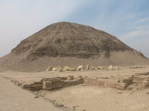
Amenemhet III, the last powerful king of the Twelfth Dynasty, built two pyramids: the Black Pyramid in Dahshur and later the Pyramid of Hawara. Thus, based on this fact, it thought that Amenemhat was buried in Hawara. The Pyramid of Hawara was built of mud brick, and then cased with fine Tura limestone. Its pyramidion was found next to the pyramid. The height of the pyramid is about 58 m and each side of its base measures about 100 m. Since the pyramid's limestone blocks were reused in later buildings, its actual aspect now resembles a small mud-brick mountain. There are also a few remains left from the mortuary temple situated to the north of the pyramid. The entrance to the pyramid lies in its southern face. Leading to a dead passage, that entrance was cunningly designed to deceive the robbers. From the passage, there were 20 tons of stones that slid sideways to open a door to a second passage leading to the burial chamber. In 1889, Petrie entered the pyramid and reached the burial chamber which is made of one huge block of quartzite, the weight of which is 110 tons. It has no door, but only a hole in its roof that was blocked with a big block of stone that weighs 45 tons. In spite of all these precautions, thieves managed to enter the burial chamber and steal many of its valuable contents.
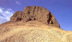
Seila Step Pyramid
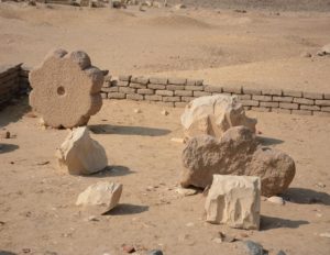
The small Step Pyramid of Seila is located a little to the south of Kom el-Hammam, opposite to the village of Robeyat, in the eastern side of Fayoum. Discovered by Borchardt in the early 1900s, the pyramid's founder was not yet identified. It was not until the 1980s that a limestone stela and an offering table were discovered inside it. Such finds had some marks and inscriptions that indicated that the pyramid was erected under the reign of King Snefru (of the Third Dynasty). With no internal chambers, the pyramid had a four stepped core built of small blocks of local limestone. Today, the pyramid, only seven meters high, is in ruins. At the base of the pyramid, archeologists found a number of rock-cut tombs bare of inscriptions date back to the Roman and Coptic Periods. Inside these burials, however, a great deal of papyri has been found. Noticeably, the Pyramid of Seila is the most northerly of seven small step pyramids that date back to the Third and Fourth Dynasties. These pyramids have neither subsidiary buildings nor burial chambers inside them.
The Workers Village
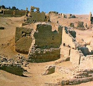
Petrie discovered the village nearby El- Lahun Pyramid, of Senusert II of the Middle Kingdom. The village's ancient name was 'Kahun'. Surrounded by walls, the village was established in a square of 384 × 335. It comprises tree districts separated by walls: the first district is the Acropolis (or the king's palace); the second had large houses of 70 or 80 rooms each; and the third had smaller houses with 4 to 12 rooms. Within its walls, the village also comprises a temple dedicated to Sopdu, a falcon god. Pottery works, household tools, statuettes, chisels, bowls, cloth, mirrors, fishing nets, furniture and many other objects were found inside the houses. Papyri containing medical and mathematical works as well as testaments dating to the reign of Senusert II were also encountered. An interesting papyrus tells about a strike the workers made many centuries before that one at Deir El-Madina.
Archeaological site of Hawara
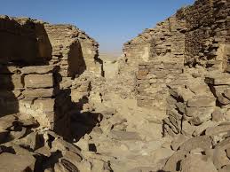
 The town of Hawara is an archaeological site in El Fayoum Governorate in the Western Desert about 9 km from El Fayoum City. In the area between Hawara and Kiman Fares, there are the ruins of the old city of Shedet, known to the Greeks as Crocodilopolis.Hawara archeological site was excavated for the first time in 1988 and a rare collection of coffins with marvelous portraits dating to the Roman Period were found in the necropolises surrounding the pyramids in the area. In Hawara, there are also the Pyramid of Amem-Em-Hat III, the intact Tomb of Neferu-Ptah (the daughter of Amem-Em-Hat III), and the Complex of Queen Sobekneferu of the Twelfth.
El Lahun Barrages
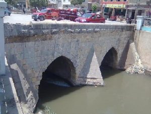
King Amenemhat III (of the Twelfth Dynasty) had much of his efforts directed to the development of investment and progress. He focused in utilizing all the country's resources, natural and human. Achieving this, he had set up the foundations of barrages at El Lahun, aiming at keeping water for the irrigation of greater agricultural areas in El Fayoum. The Lahun Barrages we see today were built by the Mameluke Sultan, Al Zaher Beybars, during the Bahari Mameluke Period over the old ones. With this construction, Beybars intended to control the water and to protect the fields from the floods of Bahr Youssef (Yusuf) Canal. They comprise two gates and measure 21 meters.
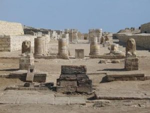
The Labyrinth
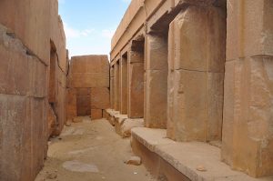
To the south of the Pyramid of Amem-Em-Hat III lies the Labyrinth which was so named by the Greek historian 'Herodotus' after the famous Labyrinth Palace in Crete. The inhabitants of the site used this temple as a quarry in the Roman times. As a consequence, it gradually disappeared except some remains of its walls and some limestone and granite columns. Some classic writers concur in that this temple exceeded all the Ancient Egyptian temples in size, reliefs, architectural design, and the number of statues set up inside it. Strabo states that the two-floor temple measures 200 m in length, with a huge number of rooms (nearly 1500) and corridors (greater than any of the Greek buildings). As Strabo remarks, this is sufficient to make any visitor get lost inside it. Inside it was found a magnificent statue of King Amenemhat III (no. 385), now exhibited in the Egyptian Museum. Despite the several trials and the huge efforts exerted by many archaeologists –including Petrie, Lloyd and others– to put a plan to this temple, through the description of writers and travelers and from its remains, they did not met with success. It is clear that the building was constructed in the reign of Amenemhat III, but was completed by his second daughter, Sobek-Neferu, the last ruler of the Twelfth Dynasty. This assumption is based on the fact that her name was found on several blocks inside the temple and there are indications that the construction of the building was still being carried out during the Second Intermediate Period. Supporting this view is the fact that Amenemhat III was paid the due reverence by his succeeding kings who added some annexes to his building in his honor.
Ruins of Dimai
The archeological site of the ruins of Dimai is situated about 8 kilometers south of Qasr el-Sagha and 45 kilometers from Kom Oshim, in El-Fayoum Governorate. Once surrounded by mud-brick walls that now still have 10 meters high, the city of Dimai was also comprises: the remains of Neolithic settlement, some ruins of the Greco-Roman town of Soknopaiou Nesos and a sphinx road that ran from the Gate of Soknopaios down to a quay on the edge of an ancient lake. Also exist are the remains of two temples dedicated to Soknopaios (another form of Sobek, the crocodile god).
Biamhu
Biamhu is an archeological site situated 7 km north of Fayoum. It includes the remains of two huge bases of limestone: each once served as a base for a colossal quartzite statue of King Amenemhat III, seated on his throne. Together with the base, the statue measured 18m in height.
Ruins of Madinet Demyet El Sebaa
pThe archeological site of the ancient Greek village of Madinet Demyet El Sebaa (Dimiat El Sabaa) is situated 3 kilometers far from Lake Qaroun. It was once used as a station for trade caravans heading to the south of the 7country or going towards the Oasis of the Western Desert. It has some remains of Greek constructions such as the ruins of a small temple built of stone. Still extant are traces of the ancient village's walls and roads.
The Roman Fortress
The Roman Fortress is located to the west of the Temple of Qasr Qaron (Qaroun). It measured about 90 by 80 meters and had square towers at each corner and semicircular towers on the sides. This mud-brick fort was built during the reign of the Roman emperor Diocletian (284-305 AD) with the purpose of protecting the city against the Blemmyes (a race of legendary creatures that were said to dwell in Africa, in Nubia, Kush, or Ethiopia). It also provided protection against potential attacks from caravans passing through the city of Qasr Qaruon (or ancient Dionysias). Though once erected of mud brick and measured about 90 by 80 m, the fortress is now in ruins. It had square towers at each corner and semi-circular towers on the sides. Within the fortress' ruins, there are a few remains of a church.
Obelisk of Senusert I
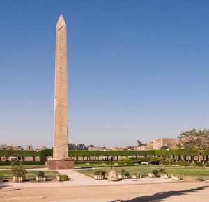
The red granite Obelisk of Senusert I measures 20.4m / 67ft tall obelisk with a round top. It was erected by Senusret I, the second king of the Twelfth Dynasty of Egypt (the Middle Kingdom). It was built in celebration of the 30th year of the King's rule and in commemoration of transferring the lands of Fayoum into agricultural areas. The obelisk was primarily set up in the village of Abgig (Abjij), then it was placed on the road to the gateway of the city of Fayoum in 1972. Interestingly, the construction has a hole intended to contain the King's crown or statue. The obelisk is decorated with extensive relief and depictions of Ankhmesut Kheperkare (Senusret I) posing before a number of deities including Horus, Amun, Isis, and Nephthys.
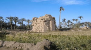
Temple of Madinet Maadi
The Middle Kingdom temple at the site was dedicated to Isis of Hermonthis, Sobek and his wife, goddess Renenutet, by Amenemhet III. Later within the Greek Period, some additions were annexed to the temple. In the first remaining courtyard, there are hymns to goddess Isis of Narmouthis. In this courtyard, multiple objects belonging to the era were discovered and they are now exhibited in the Greco-Roman Museum in Alexandria. The entrance of the Middle Kingdom part is flanked by sphinx road and some Greek construction. Here, there are scenes which picture the Ptolemaic Kings worshipping and making offerings. Also engraved is a relief of goddess Hermonthis suckling her son. The following two intact dark sandstone rooms belong to the Middle Kingdom. On the rooms' walls are depicted scenes of Amenemhet III and Amenemhet IV making offerings to Sobek and Renenutet. In other depictions, the purification of the King undertook by Sobek and Anubis is shown. In the area, there is a second temple that belongs to the Ptolemaic Era. It comprises two courtyards added by Ptolemy IX Soter II, a central chapel, an altar, in addition to smaller rooms. The sphinx road that leads to the Middle Kingdom temple also belongs to this temple.
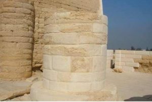
The Temple of Qasr Qaroun
The Temple of Qasr Qaroun (Qarun) lies at the far western end of Lake Qaroun. The main temple which was dedicated to Sobek-Ra dates back to the Ptolemaic Period. The temple was restored and its original ceiling is still extant. Decorating the entrance portal is a winged sun disc, a symbol of Horus, the protecting God of the entrances of ancient Egyptian temples. The interior of the temple consists of so many rooms, which made ancient travelers thought it was to be the famous Labyrinth. There is a stairway that leads to the roof that was once supported by four pillars. From atop the roof, one can enjoy a gracefully appealing view of the desert and see the cemetery of the old town as well as two wells. Although one can notice that the temple is almost bare of inscriptions, the walls of the roof have the temple's only engraving depicting god Sobek, the crocodile god. The smaller mud-brick temple, dedicated to Sobek-Ra, dates back to the Greco-Roman Period.
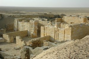
Qasr el-Sagha Temple
The Temple of Qasr El-Sagha ('Qassr El Sagha' or 'Kasr El Saga') lies above the northern shore of Qaroun Lake, about 30 kilometers from Kom Oshim, in the governorate of El-Fayoum. First published by Schweinfurth in 1892 and visited later by Petrie, this temple rests on a level platform on the side of the escarpment. Although its date is not yet identified, the temple's plan indicates that it was erected at the Middle Kingdom. The limestone blocks used in the construction of the temple were cut in different sizes and were fit tightly together using neither mortar nor oblique corner joints. The temple was neither completed nor decorated. Inside the temple's inner part were found seven small chambers and an offering hall. There is also a 'blind room', completely enclosed without an entrance. Besides the remains of this Middle Kingdom limestone temple, there are some petrified remains of a forest and others of prehistoric villages.
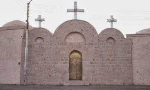
Monastery of El Azab
Built during the twelfth century, the Monastery of El Azab dates back to the Roman Era. The nearest monastery to Fayoum City, it is located in the Azab Village, 5 km south of Fayoum. It is also known as Deir Al-Adrah (the Monastery of Virgin Mary) and the Monastery of (Abu Seifein) St. Mercurius. It was identified as the Monastery of Anba Abraam since it is the burial place of St Abram, the revered Bishop of Fayoum and Giza between 1882 and 1914, whose portrait is said to reach out and shake hands with blessed visitors. The monastery comprises a liberary, a sanctuary for Anba Abraam, a garden, as well as a Coptic museum and a building for meetings and conferences. Enclosed within the monastery are five churches: the Church of Al-Adrah (Virgin Mary), the Church of Anba Beshoi (Bishoy), the Church of Abu Seifein (St. Mercurius), the Church of Anba Abraam, and the Church of Samuel. Being of great significance, this monastery draws many Coptic visitors on Fridays and Sundays.
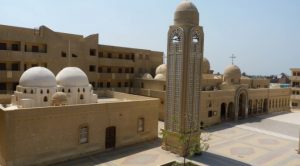
Monastery of Deir El Malak
The Monastery of Archangel Gabriel (also known as Deir El Malak Ghubriyal and Deir al-Naqlun) is a Coptic Orthodox monastery near the city of El-Fayoum, in the Western Desert. The actual monastery occupies a small portion of the original complex. Nevertheless, it is one of oldest Coptic monuments in Egypt that dates to the 5th century. Within the enclosure of the monastery, there are remains of a massive tower and a ruined church. The actual church of the Archangel was completely rebuilt in the 19th century. It comprises three sanctuaries: the central one is dedicated to the Archangel, and the other two to Virgin Mary and Saint George. Noticeably, it is divided into four sections: the sanctuary, the choir, the section of parishioners and the narthex. And the four are separated from each other with iconstases. Near the monastery, cut-rock hermitages annexed to the monastery were found.
Tomb of Neferu-Ptah
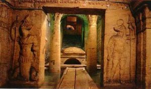
In 1956, the Egyptian Antiquities Service started digging in the area south-east of the Pyramid of Amenemhat III where the Tomb of Princess Neferu-Ptah (Neferuptah) was discovered. The tomb's owner was the daughter of Amenemhat III. She was one of the first royal women whose name was written inside a cartouche. Among the titles she held were "member of the elite, great of favour, great of praise and beloved king's daughter of his body". Although she never had the title 'king's wife', she must have had a special status. A burial for her was prepared in the tomb of her father at Hawara. However, she was not buried there, but in a small pyramid at Hawara. Inside her tomb was found a big pink granite sarcophagus, some three silver vessels, as well as a magnificent collection of gold jewelry and semi-precious stones (now on display in the Cairo Museum). Inside the granite sarcophagus which was inscribed with a short offering formula, there were found decayed remains of two wooden coffins.
Wekalet EI-Magharbah
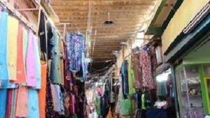
Wekalet EI-Magharbah lies in Al-Kasaba Street, in the city of El-Fayoum. It is an ancient Islamic marketplace with wooden gates and a central courtyard. Within this courtyard, there is a number of shops and an inn which once hosted a great numbers of Moroccan merchants.
Minaret and Dome of Sheikh Ali EI-Rouby
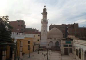
This Islamic monument is located in Al Sufi Street, in the city of Fayoum. The Minaret and Dome of Sheikh Ali EI-Rouby (El Roubi) were built by the Mameluke Sultan Barqouq in 1488 AD- 893 AH in commemoration of the Muslim hermit Sheikh Ali El Rouby, who lived in El-Fayoum. The dome is built of mud brick and the Minaret imitates one of the Minarets of Al-Azhar Mosque (in Cairo). The mosque was restored by Emir Abdel Rahman Katkhuda in 1780 AD- 1120 AH.
Qaitbay Mosque
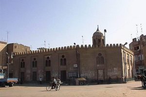
Ashraf Qaitbay was a Mameluke Sultan of Egypt in the 15th century. He was widely famous for his construction plans all over the country. He built a famous citadel in Alexandria holding his name. The reason for building this mosque lurks in his frequent visit to the city of Fayoum. The Mosque of Qaitbay has a dome raised over ancient Pharaonic columns that once belonged to a temple in Kiman Fares. Water comes to the mosque's ablution well directly from the canal of Bahr Youssef (Yusuf). The Minbar (or the pulpit) is a beautiful wooden artwork inlaid with ivory.
The Hanging Mosque
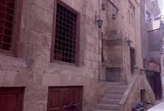
The Hanging Mosque in El Fayoum was so named because Prince Suliman Ben Hatem (also known as Soliman Ibn Mouhamed), Governor of Fayoum, built it on a hill during the first years of the Ottoman Period, in 1375. Some of the mosque's blocks were taken from earlier Pharaonic and Greco-Roman buildings. The mosque comprises a double flight of stairs leading to the main door.
